Chapter 11
By Boat Across Florida
Sept to Dec 1992
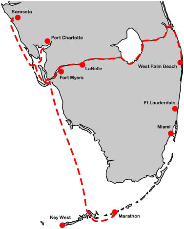
From Marathon in the Keys we cruised north across Florida Bay to the west coast of
Florida, spending almost a month in Port Charlotte doing interesting things like
getting married and renting a van to visit the Salvador Dali museum in St Petersburg
and buying a load of art supplies and construction materials. We also bought two huge
loads of groceries to carry us through the upcoming winter in the Bahamas. Oborea
was two inches deeper in the water than she had ever been!
In mid October at Boca Grande, the mouth of Charlotte Harbour, we met up with our
friends David and Neila on their catamaran Windchime and together sailed north to
Sarasota. There we spent another month and built our new refrigerator, completed the
new hatches over the bunks and repaired a damaged section of rub-rail. By the end of
November it was time to head to the east coast on our way back to the Bahamas.
We said goodbye to David and
Neila and sailed south forty
miles back to Boca Grande. We
left a bit late and the winds
were light so it was after dark
before we made the inlet, but
while still in the gulf we had a
school of dolphin play around
our bows for twenty minutes,
their forms outlined in
phosphorescence as they dived
beneath us. We anchored for
the night a mile inside the cut. The next day was mostly calm and
we motored down Pine Island sound and into the mouth of the
Caloosahatchee River, heading inland and anchoring for the night
off Cape Coral. The following morning we listened to the
countdown as a space shuttle took off from Cape Canaveral, and
ten seconds later we saw the smoke trail climbing into the air 130
miles dead ahead of us. It lingered for many minutes until it was
finally scattered by the wind. The calm at our level continued however and we motored on up the Caloosahatchee and
through the first lock of the Okeechobee waterway at Franklin.
Oborea has made more than 120 passages through 52 different locks and we thought we had seen it all, but the five locks
on the Okeechobee Waterway have no sluices, they fill and empty them by opening the main gates! It was a bit alarming
the first time to see the gate at the head of the lock open a foot to admit an eight foot waterfall but there was surprisingly
little turbulence.
Once above the first lock we were in the rural interior of Florida,
travelling through marshes or cattle ranches. Spoil banks rim much
of the river and we had to climb a few feet up the mast to see over.
We stopped that night at the town of LaBelle which has a small
public dock with room for three of four boats; these were all taken
however and we anchored fore and aft near the north bank of the
river and rowed in. LaBelle is a farming community serving a
considerable area and for its size has a huge supermarket and
excellent hardware store. This is possibly the best supply stop on
the Okeechobee Waterway.
Two more locks the next day raised us to the fourteen foot elevation
of Lake Okeechobee at Moore Haven. We took on fuel at a marina
while an alligator basked on the opposite bank. Lake Okeechobee is
over twenty miles in diameter, but is very shallow. The deepest
sounding is about fourteen feet, while the whole southwestern part
of the lake is a sawgrass swamp, not navigable by conventional
boats. In years gone by hurricanes used to blow the water out of the
lake and flood the surrounding countryside, so in the 1930's a dyke
or levee was built completely around the lake to contain it. This makes the water completely invisible from the highways
that follow around it, and from the lake the only signs of towns are the tops of water towers; it is like a secret lake. The fill
for the levees was taken from the lake and this has formed a deep channel all the way around the edge, the Rim Route. It is
10 miles longer than the route across the center of the lake, but there is a lot more to see, and it is perfectly protected in
bad weather.
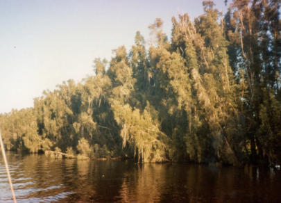
For the first part of the rim route it was hard to tell we were on a lake
at all, both banks of the channel are heavily forested and festooned
in spanish moss, real bayou country. When it was possible to get a
glimpse toward the lake all that was visible was a sea of grass. We
anchored fore and aft in one of the wider parts of the channel and at
sunset the mosquitos came out in force, millions of them and all
hungry. Luckily Oborea has full screens and we beat a hurried
retreat below. All night weird cries of marsh birds echoed around us
and the frogs sang their lungs out—the whole choir from trebles to
basses.
Before first light the bass boats were out, small high speed planing
hulls with huge outboards. They roared off into the swamp in all
directions to their favourite fishing holes and were soon gone with
little wake, leaving us to putt along in the early morning mist
surrounded by birds—birds everywhere. We saw seven varieties of
heron and egret. Cormorants and their fresh water cousins the
anhingas dried their wings on either bank. Gulls and terns flew
overhead while ospreys and kingfishers defended their territories. In
the tall trees turkey vultures roosted overnight and turned their backs to
the rising sun with spread wings to absorb its warmth, and as soon as the
ground warmed up too they were off riding the thermals hundreds of feet
into the air without a flap of their wings.
The eastern part of the rim route at last opens out. It still follows the
shore close to starboard, but on the port side the open water of the lake
extends to the horizon. That evening we headed out a mile into the calm
lake to anchor well away from the bugs off Port Myaca, the eastern exit
from the lake.
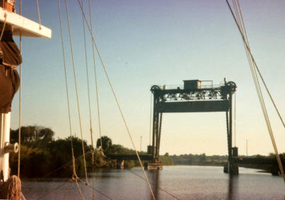
Just below the lock at port Myaca is a railroad lift bridge with an open
clearance of 49 feet, this is the limiting clearance for the whole waterway
and keeps out a lot of sailing yachts, but we would just make it.
(minimum depth of the waterway is six feet, and width 50 feet) and then
we were into the St Lucie Canal, long straight reaches through citrus
orchards (although they were again often hidden behind high banks) to
the St Lucie lock that lowered us to the St Lucie river and sea level. The
river here winds through mangrove swamps which have in spots been
drained and cleared for enormous Florida mansions. At Stuart the river
broadens out and was full of boats (during the previous 150 miles of the
waterway if we saw five other yachts it was a busy day) and five miles
farther on we rejoined the familiar waters of the Atlantic Intracoastal
Waterway between Fort Pierce and West Palm Beach. We turned south to
Lake Worth to do some last minute shopping and to await a weather slant
to carry us back across the gulf stream to the Bahamas.
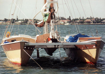
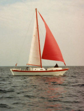

Sarasota refit
Okeechobee shoreline
Port Mayaca bridge