Chapter 6
On to the Bahamas
Dec 1991 to Feb 1992
US Route One runs from the Canadian border in New Brunswick, south and west across the States to the southern tip of
Florida; it then skips another one hundred miles across the keys to Key West. Between the southern tip of mainland
Florida and Key Largo it runs across a causeway between Card Sound and Blackwater Sound. This section of US1 is known
locally as “The Stretch'' because it runs eighteen miles without a bar.
The stretch is two lanes wide and runs for the most part dead straight with only a couple of gentle curves, first through
everglades country of sawgrass and hardwood hammocks and then between mangroves which shut out all but brief
glimpses of the shallow water close on each side. Half way along and unnoticed by all but a few of the thousands of
vehicles that come and go to the keys every day a small turnoff leads to the east between the mangroves and casuarinas.
Blink and you will miss it. The road runs for a quarter of a mile beside a winding creek past a small boatyard and a couple
of nondescript marinas to a tiny campground and restaurant at the tip of Point Laura. In the bay beyond the creek a dozen
more boats lie at anchor. Most of the boaters and campers here are permanent residents. Liveaboards. The Point Laura
Restaurant is run by a cruising couple that swallowed the anchor and settled down, and the bar hosts as eccentric a group
of regulars as you could hope to meet. In this little enclave, far from the flash and dazzle of the rest of The Keys, we spent a
month helping our friends David & Neila get their boat ready to sail again.
Finally on New Year's Eve Windchime's shiny new red
mast went up and a day later the Toronto catamaran Ru
arrived, her crew looking like tanned old salts and full of
tales of their trip down the Intracoastal (they had less rain
than us, but just as cold).
Here in the bay we waited until conditions were right to
cross the Gulf Stream, a voyage never to be undertaken
lightly. The current running north at over three knots
kicks up a really nasty sea against any wind with north in
it, the prevailing easterlies are headwinds and if the wind
swings to the south it is usually the precursor of a cold
front and its following “norther''. What you try and do is
leave when the wind swings far enough south of east and
get across ahead of the cold front.
On the ninth of January conditions seemed good; light
south easterlies predicted to swing gradually to the south
west. We said our goodbyes to David & Neila (family
commitments prevented them making the crossing with
us; three Narais crossing the Gulf Stream in formation would have been quite a sight!) and in the early afternoon we set off
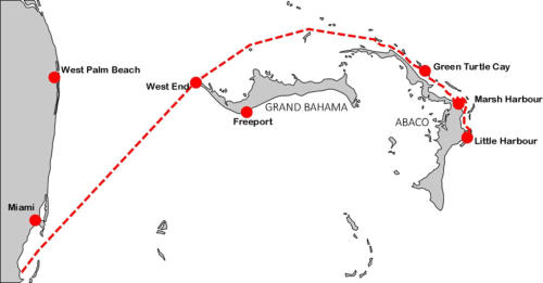
up the coast to Fowey Rocks, south of Miami, our jumping off point for the eighty five mile trip to Grand Bahama.
We entered the lumpy swells of the Gulf Stream just after seven in the evening but it soon smoothed out into the gentlest
crossing I have experienced. Under a sky brilliant with stars the warm breeze on the beam pushed as along at about four
knots through the water (more than six knots over the bottom). The lights of commercial shipping faded astern as we drew
away from the American coast and soon there were only the lights of a couple of other yachts. We navigated by dead
reckoning and radio bearings while André used his LORAN and we compared positions. Ru was considerably slower than
us (his crew claimed it was because of the ton of books André brought!) and so they ran their engine every few hours to
catch up. We kept in sight until early next morning in the North West Providence Channel a few miles off Grand Bahama
when André turned off for Freeport as one of his crew had a flight to catch while we carried on toward West End. We
stayed in radio contact until they entered the marina and they were supposed to catch us up in a couple of weeks but so far
it has been a month and we have seen no sign of them.
I am still using the 1984 edition of The Yachtsman's Guide
to the Bahamas and each time I have passed on or off the
banks at West End more of the charted markers have been
missing. In André's 1991 edition it said all the markers
were now gone, and as the resort at West End is now
closed, the status of the marina (and customs port of entry)
is uncertain. Well for you planning the trip this year here is
the latest: as of January: the marina (and customs) is still
open, although we did not stop there, and all the markers
for Indian Cay Channel have been replaced in their charted
positions and there are two new ones marking each side of
the entrance from deep water. In typical Bahamian fashion
though the markers (wooden piles) are not identified by
colour or numbers, you have to figure out which is which
and on which side each should be passed.
We carried on over the banks to Mangrove Cay (which has
a new lighted marker a hundred yards off its north point)
where we anchored for the night. In the early morning
hours a cold front passed through, but it was a weak one and we used the following norther to beam reach at seven or eight
knots to Allens-Pensacola Cay where we had our first swim in turquoise Bahamian waters from the deserted ocean beach.
The next day we tacked against headwinds to Green Turtle Cay where we officially entered. Cruising permits are still free
and are now good for a year instead of six months. Fishing licences still cost ten dollars but are now good for only three
months instead of a year. On the ocean side of the island Iris went for her first snorkel over coral reefs, had her first
encounter with barracuda and rays, and found two fine conch. An hour later they were fritters. Miss Emily's Blue Bee Bar
is still going strong and at the Rooster's Rest bar they had CBC Northern Services tuned in on the satellite and we watched
forecasts of blizzards and minus thirty degree temperatures for Tuktoyaktuk and Iqaluit (and for some reason, the
Vancouver Evening News) while we sipped our rum punches.
Continuing southeast through Whale Cay Passage we got a shock. There used to be a
lovely bay at the north west end of Great Guana Cay, six to eight feet deep with a mile
long white beach that was completely deserted unless there happened to be another
yacht at anchor. A short trail led across the island to an even more beautiful beach on
the ocean side. It has all changed. A thirty foot deep channel has ben dredged to a
turning basin with huge mooring buoys and a new island has been thrown up from the
dredged material. Great cruise ships moor off the bay and ashore there are now beach
bars, deck chairs, windsurfer rentals, para-glide rides, boats and people everywhere, a
cordoned off area for swimming and, saddest of all, an enclosure for captive dolphins.
I suppose the wild ones could not be relied upon to show up on cue. We left this
desecrated bay after one night and headed on for Marsh Harbour.
Marsh Harbour is not pretty but it is the supply base for the Abaco Cays where
everything is available from wholesale groceries to hardware. Little has changed since
my last visit except for a shiny new laundromat. To a visitor arriving straight from
Canada the prices do not seem quite as outrageous as they do to someone arriving
from the states. Many prices are comparable and we even found some Canadian made
products that are cheaper here: cigarettes and yeast for baking. I do not think this
reflects any change in the prices here but rather its an indication of how much things
have risen in Canada in the last few years. From Marsh Harbour we sailed to Hope
Town where we spent a couple of days anchored below the candy striped lighthouse
and then we continued on south to Little Harbour.
The community at little Harbour had its beginnings in the nineteen fifties when
Canadian born sculptor Randolph Johnston and his family arrived in the then
uninhabited cove and decided to stay. They hacked out a clearing to build a home and
a studio and even a foundry for casting Randolph's sculptures in bronze. Over the
years a few Americans built winter homes around the bay and along the Atlantic
shore, but the community remained small. Access was only by boat and Marsh Harbour was twenty miles away.
Randolph's son Pete became a sculptor in his own right and also built a little pub to welcome visitors, mainly yachtsmen
who could negotiate the 3.5' LW channel.
But all this too has changed.
Four years ago a road was built into Little Harbour. “Road''
is a loose term—it takes over an hour to drive the twenty
miles to Marsh Harbour in dry weather, in wet it becomes
impassable. But it brought development. New houses are
going up and scars are appearing on the hillsides as the
bush is cleared for homesites. Randolph Johnston, now in
his eighties, suffered a stroke last year and is largely
incapacitated, but Pete is carrying on the business. A new
building is going up to house an enlarged gallery and a
small restaurant and they have even opened a branch
gallery in Marsh Harbour.
We have been here for three weeks now doing a lot of
painting and helping about the place (we have friends here)
But the weather has not been particularly good—one cold
front has followed on the heels of another without a break
so we are thinking of heading on soon—south to the Exumas where it is warmer.

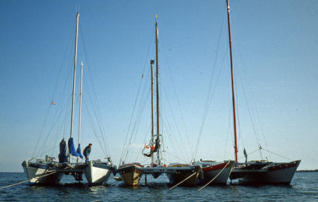
Three Wharram Catamarans
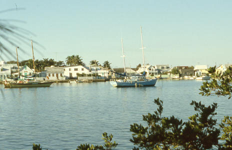
Green Turtle Cay
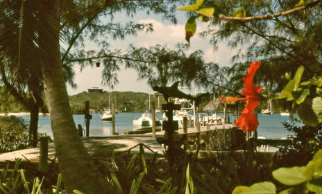
Hope Town
Little Harbour